
 By Vincent Villatte
In this article, we'll explore the numerous benefits of using on-map measurement tools when preparing missions for drone operations in ScaleFlyt.
In recent years, the use of drones has soared to new heights, revolutionising industries in all sectors of activity. One key factor behind the success of these unmanned aerial vehicles (UAVs) is meticulous planning and execution of missions. To ensure successful drone operations, it's essential to use every tool available for precise planning, and one such tool that has become indispensable is the on-map measurement tool. In this article, we'll explore the numerous benefits of using on-map measurement tools when preparing missions for drone operations with the ScaleFlyt platform.
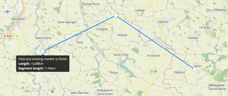
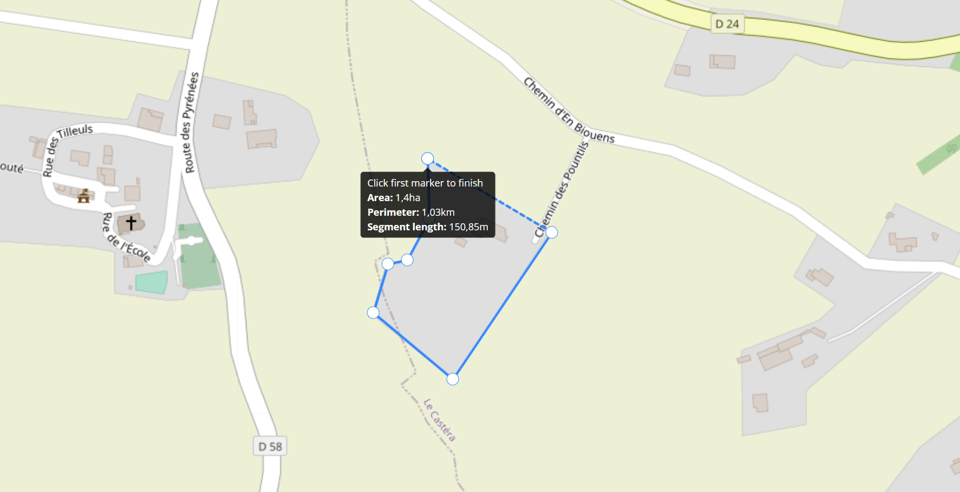
Accurate measurements are paramount in drone mission planning. Whether you're mapping a construction site, monitoring crop health, or assessing the damage after a natural disaster, precision matters. ScaleFlyt's newly added on-map measurement tools provide you with the ability to measure distances, areas, and volumes directly on a map. This precision allows you to plan flight paths, identify specific areas of interest, and ensure that your drone collects data with pinpoint accuracy.
Efficiency is another crucial factor in mission planning. On-map measurement tools streamline the planning process by eliminating the need for manual measurements on-site. You can quickly calculate distances, areas, and volumes without physically visiting the location, saving both time and resources. This not only speeds up mission preparation but also enables you to respond promptly to changing conditions or new project requirements. Incorporating precise measurements into your drone mission planning empowers you to make data-driven decisions. By accurately assessing distances and areas, you can optimise flight paths based on your drone's capability to cover the entire area of interest or focus on specific regions that require closer attention. This data-driven approach ensures that your drone collects the most relevant information, enhancing the overall effectiveness of your mission.
Efficient mission planning doesn't just save time; it also saves money. By optimising your drone's flight path and data collection strategy, you reduce the need for additional flights or data reprocessing. This not only lowers operational costs but also maximises the return on investment for your drone technology. As your drone operations grow, the scalability of on-map measurement tools becomes increasingly valuable. These tools can handle a wide range of mission sizes and complexities, from small-scale inspections to large-scale surveillance projects. This scalability ensures that your mission planning remains efficient and effective, regardless of the scope of your operations.
Safety is paramount in drone operations. On-map measurement tools help mitigate risks by enabling you to plan safe flight paths that avoid obstacles, such as buildings, trees, or power lines. By visualising potential hazards and adjusting your mission to keep a safe distance, you reduce the likelihood of accidents and minimise the chances of damage to your drone, property and people.
In addition, any countries have strict regulations governing drone operations, particularly regarding distances from people and structures. On-map measurement tools can help you remain in compliance with these regulations by accurately determining distances and boundaries. This ensures that your drone operates within the legal parameters, reducing the risk of regulatory fines or legal issues.
The benefits of using ScaleFlyt's newly added on-map measurement tools in drone mission planning are evident: enhanced precision, time efficiency, data-driven decision making, improved safety, regulatory compliance, cost savings, and scalability. With the continuous expansion of the drone industry, these tools are becoming essential for professionals across all sectors. We've integrated these tools to help you harness the full potential of ScaleFlyt's mission planning capability. Incorporating on-map measurement tools into your mission planning process is a smart investment that not only improves the quality of your data but also streamlines your operations for greater success.
Become part of the community shaping the future of operational drone management, today.

