
 By Nick Goundry
We are delighted to announce our biggest ever upgrade to SOARIZON's intelligent mapping functionality.
The new map enhancements mean that users are able to plan their missions on SOARIZON to an even higher level of detail and precision, with more information helping to inform risk mitigation, and provide a greater degree of mission visibility across the your organisation.
Based upon continuous user testing and rapid prototyping, the SOARIZON map has undergone a complete overhaul, with the key addition of brand new map annotation tools. These enhancements mean that users can now benefit from the following:
This exciting capability allows SOARIZON users to define their missions accurately by annotating flight volumes, contingency volumes and risk buffers in 3D. We’ve added this in to help you to create rich planning maps to support your mission planning, in alignment with new drone regulations coming into force in 2021, and risk assessment processes.
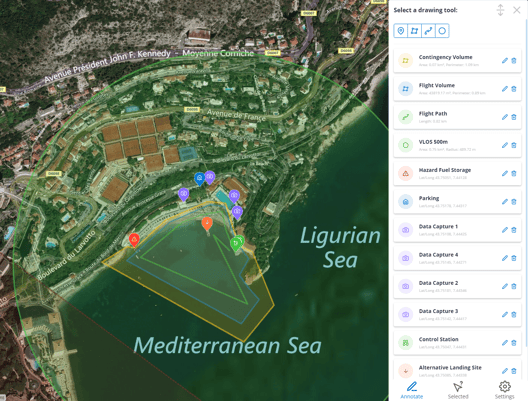
In SOARIZON you now have a set of drawing tools which can be customised by colour, title, and description to enable the creation of a rich and detailed drone plan. You now also have the option to mark take-off and landing points on the map.
Compatible with mobile and tablet devices, you are able to view and edit annotations out in the field. For SOARIZON Elevate and Enterprise customers, these plans can be edited collaboratively within your Organisation, keeping the map as a live record throughout the life-cycle of the mission.
The new upgrades have been designed with a new sleek and intuitive functionality, specifically developed for maximum usability and ease of access.
Now you can tailor your mission plan to suit you, with SOARIZON's versatile and comprehensive map features.
You can experience these fantastic new upgrades, whilst still benefitting from all of the original SOARIZON map features:
This isn't the only change we'll be making to the map. We're already developing the next release which will give you the ability to import and export annotations in the KML format, which will allow you to share your mission plans between different applications.
Best of all, the new map annotation features are available to all SOARIZON users, free of charge. Sign up for your free SOARIZON account today and start bringing efficiency and compliance to your drone operations.

Become part of the community shaping the future of operational drone management, today.

